Facility location modeling in future cities
With the population and economic growth, new urban facilities have been widely planned or built in our cities. However, due to the limited space, budget and resources, optimally locating those facilities is key to guarantee social equity in public service provision as well as to achieve the maximum socioeconomic benefits. In this research work package, we attempt to develop and apply spatially explicit location models to assist with decision-making in relation to site selections in both public and private sectors. More details can be found on the UBDC urban governance research package.
Related Publications:
1. Zhao, Q., Dickson, C., Thornton, J., Solís, P., & Wentz, E. A. (2020). Articulating strategies to address heat resilience using spatial optimization and temporal analysis of utility assistance data of the Salvation Army Metro Phoenix. Applied Geography, 122, 102241. https://doi.org/10.1016/j.apgeog.2020.102241
2. Zhao, Q., Kelley, S. B., Xiao, F., & Kuby, M. J. (2019). A multi-scale framework for fuel station location: From highways to street intersections. Transportation Research Part D: Transport and Environment, 74, 48–64. https://doi.org/10.1016/j.trd.2019.07.018
3. Zhao, Q., Wentz, E. A., & Murray, A. T. (2017). Tree shade coverage optimization in an urban residential environment. Building and Environment, 115, 269–280. https://doi.org/10.1016/j.buildenv.2017.01.036
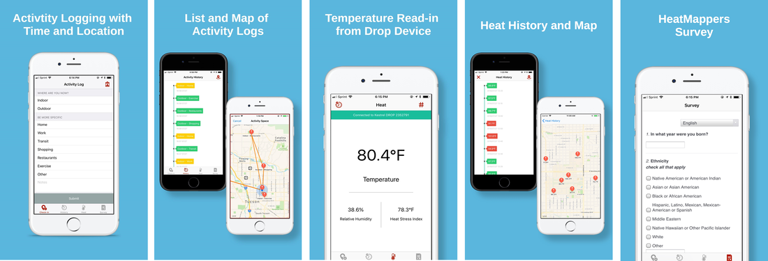
Human activity space, portable sensing, and spatial analytics
Various portable sensors, smartphone apps, and user-generated data have now been widely used to understand human mobility and activity space in the urban areas. In this research work package, we attempt to use different sensor technologies together with newly designed smartphone apps to understand the human behaviors and activities in the changing cities. Advanced spatial analytical methods and GIS have been used to achieve the research goal.
Related Publications:
1. Zhao, Q., Shah, D., Li, Z., Fischer, H., Solis, P., & Wentz, E. (2019). ActivityLog: An Integrated Citizen Science Platform for Urban Climate Research. Manuscript in preparation. (ActivityLog App Information: Download at App Store or Google Play, credit to Dr. Ziqi Li)
2. Kuai, X., & Zhao, Q. (2017). Examining healthy food accessibility and disparity in Baton Rouge, Louisiana. Annals of GIS, 23(2), 103–116. https://doi.org/10.1080/19475683.2017.1304448
3. Yabiku, S., Glick, J., Wentz, E., Ghimire, D., & Zhao, Q. (2017). Comparing Paper and Tablet Modes of Retrospective Activity Space Data Collection. Survey Research Methods, Vol 11, 329-344 Pages. https://doi.org/10.18148/srm/2017.v11i3.6741
4. Zhao, Q., Wentz, E., Fotheringham, S., Yabiku, S., Hall, S., Glick, J., … Heavenrich, H. (2016). Semi-parametric Geographically Weighted Regression (S-GWR): A Case Study on Invasive Plant Species Distribution in Subtropical Nepal. International Conference on GIScience Short Paper Proceedings, 1. https://doi.org/10.21433/B3118kv3n3bq
Urban climate modeling and instrumentation
City is a new climate 'testbeg' and 'laboratory'. The rapid change of earth surface in the urban areas create new climate questions and challenges for urban residents. In this research work package, we intend to integrate social and physical science in the urban climate domain to develop and test urban design/management/governance policies and strategies that enhance the productivity, health, and sustainability of urban populations. Specific topics include extreme heat, air quality, flooding & drought, urban ecology, and infrastructure services including energy, water, housing, and transportation.
Related Publications:
1. Zhao, Q., Sailor, D. J., & Wentz, E. A. (2018). Impact of tree locations and arrangements on outdoor microclimates and human thermal comfort in an urban residential environment. Urban Forestry & Urban Greening, 32, 81–91. https://doi.org/10.1016/j.ufug.2018.03.022
2. Zhao, Q., Yang, J., Wang, Z.-H., & Wentz, E. (2018). Assessing the Cooling Benefits of Tree Shade by an Outdoor Urban Physical Scale Model at Tempe, AZ. Urban Science, 2(1), 4. https://doi.org/10.3390/urbansci2010004
Urban remote sensing
Remotely sensed images and the analytical techniques to extract information from the imagery offer a comprehensive approach to monitor and observe urban environment in real time through high spatial-temporal-spectral-resolution data globally. One of the main challenges of urban remote sensing is that the sensors (and the subsequent data) were not originally designed to extract information from urban areas. In this research work package, we attempt to incorporate the newest remote sensing data advancement to understand the complex urban environment and answer urban-related social, economic, and environmental questions.
Related Publications:
1. Zhao, Q., & Wentz, E. A. (2020). Editorial for the Special Issue: “Remote Sensing of Urban Ecology and Sustainability.” Remote Sensing, 12(3), 443. https://doi.org/10.3390/rs12030443
2. Zhao, Q., & Wentz, E. A. (2016). A MODIS/ASTER Airborne Simulator (MASTER) Imagery for Urban Heat Island Research. Data, 1(1). https://doi.org/10.3390/data1010007
3. Zhao, Q., Myint, S. W., Wentz, E. A., & Fan, C. (2015). Rooftop Surface Temperature Analysis in an Urban Residential Environment. Remote Sensing, 7(9), 12135–12159. https://doi.org/10.3390/rs70912135
4. Wang, Z., Fan, C., Zhao, Q., & Myint, S. W. (2020). A geographically weighted regression approach to understanding urbanization impacts on urban warming and cooling: A case study of Las Vegas.” Remote Sensing, 12(2), 222. https://doi.org/10.3390/rs12020222
5. Wang, C., Li, Y., Myint, S. W., Zhao, Q., & Wentz, E. A. (2019). Impacts of spatial clustering of urban land cover on land surface temperature across Köppen climate zones in the contiguous United States. Landscape and Urban Planning, 192, 103668. https://doi.org/10.1016/j.landurbplan.2019.103668
6. Zhao, Q., Reynolds, R., Wang, C., & Wentz, E. A. (2019). A multidimensional urban land cover change analysis in Tempe, AZ. 2019 Joint Urban Remote Sensing Event (JURSE), 1–4. https://doi.org/10.1109/JURSE.2019.8808957
7. Wentz, E. A., & Zhao, Q. (2015). Assessing validation methods for building identification and extraction. 2015 Joint Urban Remote Sensing Event (JURSE), 1–4. https://doi.org/10.1109/JURSE.2015.7120453
